-
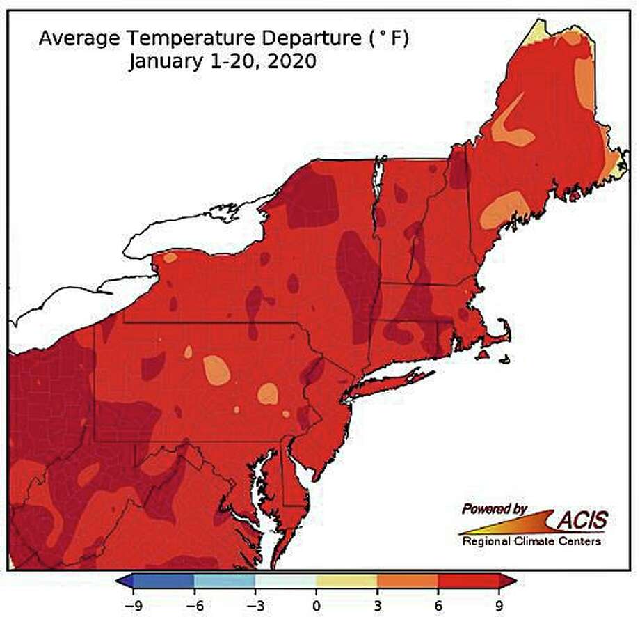 Photo: Shay, Jim
A coastal low pressure system that is expected to develop this weekend is expected to have little - if any - effect on Connecticut.
No raging nor’easter with heavy snow or strong winds is expected.
Instead, the National Weather Service says there is only a 30 percent chance of snow before noon Saturday, then a chance of rain and snow.
The low pressure system is expected to develop off the Mid-Atlantic coast early Saturday and move southeast of the “40/70 Benchmark.”
The “benchmark” is the geographic reference point of 40 degrees north latitude and 70 degrees west longitude off the New England coast.
When a storm tracks outside (or east) of the 40/70 benchmark, it typically brings snow to Connecticut and the New York metro area. If the low pressure system moves inside (or west) of the benchmark, there is a better potential for rain or mixed precipitation.
“This will keep the area on the northwest flank of the storm with a low chance of precipitation Friday night into Saturday night, with the highest probability across coastal locations,” the NWS says in its forecast discussion.
The storm is expected to strengthen in the Atlantic Ocean when it is well east of New England.
“Thus, have opted for only low chances of rain and snow. No snowfall accumulations are forecast at this time with the liquid equivalent amounts likely to be less than a quarter inch. It`s quite possible that the area stays dry this weekend. The trend is toward less impact,” the NWS says.
After a cold start Friday morning with high pressure across the area, temperatures will remain above normal by about 5 degrees with highs around 40 and lows in the upper 20s to lower 30s.
Conditions will quickly warm up going into next week. This will be accompanied by temperatures getting well into the 40s Monday and Tuesday with the possibility of the lower 50s in some spots.
An approaching warm front Monday night into Tuesday will produce increasing chances of rain.
Wintry weather seems unlikely with warm air aloft and lows across the interior Tuesday morning in the lower 30s to start.
The Northeast Regional Climate Center says January’s average temperatures are about 7.5 degrees above normal.
On Jan. 12, Bridgeport, Boston, and Providence had their warmest January day on record with highs ranging from 69 to 74 degrees.
The Climate Prediction Center says the first week of February in the Northeast has a 60 percent chance of above average temperatures.
The forecast
Today: Mostly cloudy, then gradually becoming sunny, with a high near 40. Wind chill values between 15 and 25. North wind 9 to 15 mph.
Tonight: Clear, with a low around 17. Wind chill values between 10 and 15. North wind 6 to 8 mph.
Thursday: Sunny, with a high near 36. Wind chill values between 10 and 20. Northeast wind around 6 mph becoming calm in the afternoon.
Thursday Night: Partly cloudy, with a low around 20. Calm wind.
Friday: Mostly sunny, with a high near 42. Calm wind becoming west around 5 mph in the afternoon.
Friday Night: Mostly cloudy, with a low around 29.
Saturday: A chance of snow before noon, then a chance of rain and snow. Mostly cloudy, with a high near 41. Chance of precipitation is 30 percent.
Saturday Night: Mostly cloudy, with a low around 29.
Sunday: Partly sunny, with a high near 41.
"impact" - Google News
January 29, 2020 at 08:58PM
https://ift.tt/2ScEtp9
NWS sees little impact in CT from weekend storm - CTPost
"impact" - Google News
https://ift.tt/2RIFll8
Shoes Man Tutorial
Pos News Update
Meme Update
Korean Entertainment News
Japan News Update
Bagikan Berita Ini


0 Response to "NWS sees little impact in CT from weekend storm - CTPost"
Post a Comment