An area of disturbed weather out over the Atlantic Ocean now is expected to develop into the next tropical storm sometime this week, according to forecasters.
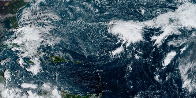
The National Hurricane Center (NHC) in Miami said Monday that an area of showers and thunderstorms have "increased in organization" and formed into Tropical Depression 27, which is located about 700 miles southeast of Bermuda.
The system has been moving out over the Atlantic for several days but has recently been getting better organized.
‘BUBBLE CURTAIN’ IS THE NEWEST CRAZY HURRICANE-KILLING IDEA
As of 8 a.m. EDT, the NHC said the tropical system has maximum sustained winds of 35 mph and is stationary over the ocean.

Tropical Depression 26 can be seen swirling over the Atlantic Ocean on Monday, Oct. 19, 2020. (NOAA/GOES-East)
Little overall motion is expected through Monday night, while the system is expected to slowly move to the northwest on Tuesday and continue through midweek.
The storm system is expected to grow stronger while over the open waters of the Atlantic.
"Gradual strengthening is forecast during the next 72 hours, and the depression is forecast to become a tropical storm later today or tonight and be at or near hurricane strength by early Thursday," the NHC said.
If it develops into a tropical storm, the system would have the name "Epsilon" from the Greek alphabet and be the 26th named storm of the season, and would break yet another record during this hurricane season.
The current record for the earliest 26th named storm formation is Nov. 22, 2005, according to Colorado State University hurricane researcher Phil Klotzbach.
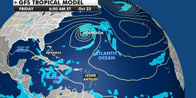
While currently there are no coastal watches or warnings in effect, Bermuda needs to monitor this system as it could impact the island on Friday.

The system may bring impacts to Bermuda by the end of the week. (Fox News)
Forecasters are also monitoring the southwestern Caribbean Sea, where a broad area of low pressure is expected to form over the next couple of days.
HURRICANE IRMA CAUSED OVER 400 SENIOR DEATHS IN FLORIDA, STUDY SAYS
"Some gradual development of this system is possible late this week while it moves slowly
northwestward or north-northwestward over the western Caribbean Sea," the NHC said.
Forecasters give this system a 20% chance of development over the next five days.
There is just over one month left in the 2020 Atlantic hurricane season, which ends Nov. 30, but this season has broken numerous records as forecasters in September ran out of traditional names and went to the Greek alphabet for storms Alpha and Beta. Delta became a Category 4 storm before weakening and swiping Mexico, then took aim and roared into Louisiana as a Category 2 hurricane.
NOAA forecasters had called for up to 25 named storms this season with winds of 39 mph or higher; of those, seven to 10 could become hurricanes. Among those hurricanes, three to six will be major, classified as Category 3, 4 and 5 with winds of 111 mph or higher.
That's far above an average year. Based on 1981-to-2010 data, that is 12 named storms, six hurricanes, and three major hurricanes.
CLICK HERE FOR MORE WEATHER COVERAGE FROM FOX NEWS
So far this year, there have been 25 named storms, including nine hurricanes and of those, three major hurricanes.
The last time the Greek alphabet was used in the Atlantic was in 2005, the year of Hurricane Katrina. With a total of 27 storms that year, the first six letters of the Greek alphabet were used: Alpha, Beta, Gamma, Delta, Epsilon and Zeta.
With weeks to go until the season officially ends, the 2020 season could set the record for most named storms.
CLICK HERE FOR THE FOX NEWS APP
Fox News' Janice Dean, Adam Klotz, and Brandon Noriega contributed to this report.
"center" - Google News
October 19, 2020 at 08:17PM
https://ift.tt/31CwC9V
Hurricane center monitoring tropical depression near Bermuda, forecast to become 'Epsilon' - Fox News
"center" - Google News
https://ift.tt/3bUHym8
https://ift.tt/2zR6ugj
Bagikan Berita Ini


0 Response to "Hurricane center monitoring tropical depression near Bermuda, forecast to become 'Epsilon' - Fox News"
Post a Comment