Tropical storms Marco and Laura have continued on their paths towards the Gulf Coast, according to the 10 p.m. National Hurricane Center update on Saturday.
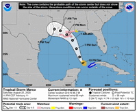
Marco, which entered the Gulf this weekend, will continue to bring tropical storm conditions over parts of Cuba tonight. Forecasters say it could be at or near hurricane strength when it nears the center of the Gulf Coast Monday.
Marco could bring storm surge and heavy rain starting midday Monday. A hurricane watch remains in effect for the Louisiana coast, including the metro New Orleans area.
Forecasters with the Slidell office of the National Weather Service said that peak winds in New Orleans should reach 40 to 50 mph with gusts up to 65. And because the two storms will arrive one after the other, that chance of high winds will last from Monday morning through early Thursday morning.
A flash flood watch remains in effect from Sunday night to Tuesday, with 4 to 8 inches of rain generally and higher amounts possible in certain areas. Forecasters expect little to no threat of tornadoes from Marco.
Higher winds are possible to the west of New Orleans, with gusts to 90 mph possible for LaPlace and Reserve and 85 mph in Baton Rouge and Hammond.
In Lafayette, forecasters with the weather service's Lake Charles office say peak winds could include gusts up to 60 mph.
Local weather service forecasters warned of potentially life-threatening wind across metro New Orleans, the River Parishes and Coastal Southeast Louisiana, ranging from considerable roof damage to sturdy buildings and snapped or uprooted large trees to large areas with power and communication outages.
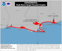
A storm surge watch for Marco is in effect for the Sabine Pass to the Alabama-Florida border and for Lake Pontchartrain, Lake Maurepas, Lake Borgne and Mobile Bay. The weather service predicts peak storm surge from Marco will reach between 3-5 feet from Grand Isle to the east and 2-4 feet for the rest of coast to the Sabine Pass.

"In sharp contrast to earlier today, no large changes were made to the track forecast, though that should not be interpreted as an increase in forecast confidence," said Hurricane Specialist David Zelinsky about the Marco forecast path.
He said Marco's intensity at landfall will depend on the wind shear it will encounter as it moves across the Gulf and warned even a brief relaxation of the upper level winds could result in a rapid intensification.
Marco is expected to move north-northwest towards the northern Gulf Coast on Monday. Once it moves inland and weakens, forecasters anticipate it will slowly turn west.

Tropical Storm Marco as of 10 p.m. Saturday
"Marco is a small tropical storm and will be susceptible to rapid changes in structure and intensity until it reaches the northern Gulf Coast," forecaster said in a Saturday night advisory.
Tropical Storm Laura, which is located close to the eastern Dominican Republic, will bring heavy rain across the U.S. Virgin Islands and Puerto Rico Saturday night and to parts of the Dominican Republic and Haiti, the Turks and Caicos, the southeastern Bahamas and central and eastern Cuba on Sunday, National Hurricane Center forecasters said Saturday night.
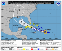
Laura is moving west-northwestward. It could bring tropical storm conditions to the Florida Keys on Monday. The storm is expected to then strengthen in the Gulf of Mexico and bring storm surge, rain and wind to parts of the U.S. Gulf coast by mid-week.
Once the storm emerges in the Gulf of Mexico, it could turn northwestern and slow down.
"The models are in fair agreement that Laura will generally follow a similar path to Marco when it nears the northern Gulf coast in 3 to 4 days," forecasters said.
"This could result in a prolonged period of hazardous weather for areas that are likely to be affected by Tropical Storm Marco earlier in the week," forecasters wrote at 10 p.m. Saturday.
Details regarding Laura's intensity and long-range tracks remain uncertain, and Saturday night's forecast for Laura at landfall was somewhat stronger than before, saying the storm could bring 90 mph winds.

Tropical Storm Laura as of 10 p.m. Saturday
Forecasters said earlier Saturday that Marco could make landfall near the mouth of the Mississippi River in southeastern Louisiana as a Category 1 hurricane late Monday afternoon. They expect Tropical Storm Laura to make landfall as a hurricane in the same general area on Wednesday.
Marco was passing through the Yucatan channel on Saturday afternoon, while Laura was dumping heavy rain on Puerto Rico on its way to the Dominican Republic.
Don't miss a storm update this hurricane season. Sign up for breaking newsletters here. Follow our Hurricane Center Facebook page here.
"center" - Google News
August 23, 2020 at 09:55AM
https://ift.tt/31l5bBx
Hurricane Center: Tropical Storm Marco continues in Gulf, could be hurricane Monday; see latest - NOLA.com
"center" - Google News
https://ift.tt/3bUHym8
https://ift.tt/2zR6ugj
Bagikan Berita Ini


0 Response to "Hurricane Center: Tropical Storm Marco continues in Gulf, could be hurricane Monday; see latest - NOLA.com"
Post a Comment