A weather disturbance in the Gulf of Mexico has a 50% chance of developing into a tropical depression within five days, the National Hurricane Center said Wednesday morning.
It could bring heavy rain and high tides to south Louisiana on Thursday and Friday, forecasters said.
UPDATE: Tropical Storm Gonzalo forms in Atlantic
Forecasters also are tracking a tropical depression, which they say is likely to strengthen into a tropical storm Wednesday in the Atlantic. If it does reach that status, it will be named Gonzalo.

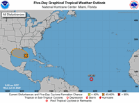
The National Hurricane Center on Wednesday, July 22, 2020, was tracking two disturbances - Invest 91L in the Gulf of Mexico and Tropical Depression 7 in the Atlantic. (Image via National Hurricane Center)
Here's what forecasters are saying as of 7 a.m. Wednesday about the tropics.
Disturbance in the Gulf of Mexico
"Gradual development" is possible for a tropical wave over the eastern Gulf of Mexico, forecasters said Wednesday morning. The disturbance is currently called Invest 91L.
It has a 40% chance (medium) of developing into at least a tropical depression within 48 hours and a 50% chance (medium) of developing into at least a tropical depression within five days.

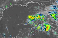
A disturbance in the Gulf of Mexico is expected to reach Texas and Louisiana later this week, forecasters said. Here's what it looks like on satellite as of Wednesday morning, July 22, 2020. (Image via NOAA)
As of 7 a.m., the weather disturbance was producing a large area of disorganized showers over the eastern Gulf of Mexico, central and southern Florida and western Cuba, forecasters said.
It's expected to move northwest and reach the northwestern Gulf by Texas and Louisiana on Thursday and Friday. Forecasters expect the center of the disturbance to stay south of the Louisiana coastline before making landfall somewhere in Texas.
The orange-shaded area on the map shows where a storm could develop, forecasters said. It is not the storm's track, which is usually released once a system organizes into a tropical depression.
An Air Force Reserve Hurricane Hunter aircraft is scheduled to investigate the system later Wednesday, if needed, forecasters said.
If the system strengthens into at least a tropical storm, it will most likely be named Hanna.
What are the threats for Louisiana?
Regardless of development, the disturbance is expected to bring locally heavy rainfall, gusty winds, dangerous lightning and higher than normal tides Thursday and Friday to south Louisiana, the National Weather Service in Slidell said Wednesday morning. Waterspouts are also possible.
The threat of thunderstorms could remain in the area into Saturday, forecasters said, and then a return to normal summertime hot weather and afternoon thunderstorms.
Read the full outlook for the disturbance.
Tropical depression in the Atlantic

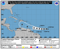
Tropical Storm Gonzalo formed Wednesday morning in the Atlantic, forecasters said. (Image via National Hurricane Center)
A small depression in the Atlantic is expected to strengthen later Wednesday into a tropical storm, the National Hurricane Center said.
As of 4 a.m. CST, the depression was 1,285 miles east of the southern Windward Islands and had become "a little better organized," forecasters said.
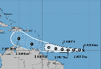
It was moving northwest at 12 mph and is expected to pick up speed in the next few days. It's expected to reach the Caribbean this weekend.
The depression has maximum sustained winds near 35 mph and strengthening is forecast during the "next couple of days," forecasters said. A tropical storm has winds at least 39 mph.
"It should also be noted that the small size of this system makes it susceptible to significant fluctuations in intensity, both upward and downward," the National Hurricane Center said.
The depression is not expected to pose a threat to Louisiana within the next five days, the National Weather Service in Slidell said. Forecast models beyond that time span are not viewed as reliable.
"Remember, we are still in hurricane season, and now is a good time to review your hurricane plans," NWS forecasters wrote in their morning update.
Read the full advisory for the tropical depression.
Reporter Mark Schleifstein contributed to this story.
"center" - Google News
July 22, 2020 at 07:18PM
https://ift.tt/3fSIPMq
Hurricane Center: 50% chance of tropical depression forming in Gulf of Mexico within 5 days - NOLA.com
"center" - Google News
https://ift.tt/3bUHym8
https://ift.tt/2zR6ugj
Bagikan Berita Ini


0 Response to "Hurricane Center: 50% chance of tropical depression forming in Gulf of Mexico within 5 days - NOLA.com"
Post a Comment