- A broad area of low pressure may become Tropical Storm Isaias in the Caribbean.
- Tropical storm warnings and watches are posted from the Leeward Islands to the central Bahamas
- Heavy rain is expected through Thursday from the Leeward Islands to Puerto Rico and Hispaniola.
- The rainfall could trigger dangerous flash flooding and mudslides.
- The forecast for this system beyond the Caribbean is highly uncertain because of multiple factors.
- First impacts could be felt in parts of Florida as soon as this weekend, but it's too early to know any details.
Tropical storm warnings extend from the Lesser Antilles to parts of the Bahamas, including Puerto Rico, as a disturbance expected to become Tropical Storm Isaias could affect Florida this weekend and parts of the eastern U.S. early next week.
The National Hurricane Center (NHC) dubbed this system "Potential Tropical Cyclone Nine" Tuesday, a procedure allowing the NHC to issue advisories, watches and warnings for a system that hasn't yet developed, but poses a threat of tropical storm-force or hurricane-force winds to land areas within 48 hours.
(MORE: Hurricane Season Terms You Need to Know)
The latest watches and warnings are shown in the map below, from the Leeward Islands to the central Bahamas. A warning means tropical storm conditions are expected in the next 36 hours. A watch means tropical storm conditions are possible within 48 hours.
Watches and Warnings
(A watch is issued when tropical storm or hurricane conditions are possible within 48 hours. A warning is issued when those conditions are expected within 36 hours.)Band of heavy rain and squalls continue to rotate through the Leeward Islands, Virgin Islands and Puerto Rico and are beginning to arrive in the Dominican Republic. At times, these bands are producing wind gusts above 40 mph.
One squall produced a 52 mph gust as it swept through St. Thomas in the U.S. Virgin Islands late Wednesday morning. A wind gust to 51 mph was clocked at San Juan, Puerto Rico, Wednesday afternoon.
Current Radar, Satellite, Watches and Warnings
(Any severe, tornado, or flash flood alerts for either Puerto Rico or the U.S. Virgin Islands will plot on the map above. )This sprawling system continues to produce ample thunderstorms, but it has not yet developed a well-defined closed low-pressure center that would allow it to be classified a tropical storm.
Assuming it does so, this system would be designated Tropical Storm Isaias (ees-ah-EE-ahs).
Below is a look at what we know about the forecast for any potential U.S. and Caribbean impacts.
Florida, Southeast U.S. Concern
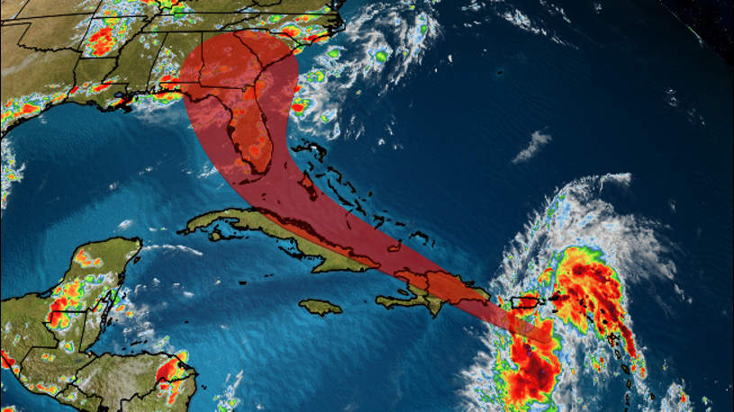
The NHC projected path below shows that this system could be located near or on either side of the Florida Peninsula by this weekend. However, this forecast is not nearly as straightforward as it might seem.
Current Information and Projected Path
(The red-shaded area denotes the potential path of the center of the system. It's important to note that impacts (particularly heavy rain, high surf, coastal flooding, winds) with any tropical cyclone usually spread beyond its forecast path.)There are a number of reasons for this uncertainty.
First, this system is in a formative state, without a clear surface low-pressure center.
Eventually, one cluster of thunderstorms may begin to take over in this large disturbance. Where exactly that occurs is uncertain, and could cause a shift to the position, and, hence, the forecast path of this system.
This system also has multiple obstacles to combat with the next few days that are important for its potential mainland U.S. future.
One of those obstacles could be a track of this system over the mountainous terrain of Hispaniola - Dominican Republic and Haiti - long known as a hurricane shredder with mountains up to 10,000 feet elevation.
The mountainous terrain of Hispaniola can significantly impact tropical cyclones and disturbances.
Hispaniola could either be a speed bump or completely shred the system as it passes through Thursday.
But there's an alternative scenario in which the main area of low pressure could finally form north of Hispaniola, avoiding the "shredding scenario" over land.
This system may also have to battle unfavorable upper-level winds - producing what meteorologists refer to as wind shear - along its Caribbean and Bahamas track. This is a nemesis of tropical cyclones.
Current Satellite, Wind Shear Analysis
(Areas of clouds are shown in white. Areas of strong wind shear, the difference in wind speed and direction with height, are shown in purple. High wind shear is hostile to mature tropical cyclones and those trying to develop.)The bottom line is that it's too early to precisely determine this system's future track and intensity, especially with regard to the mainland U.S.
It's even possible the system could be ripped apart, or at least weakened by any of the aforementioned obstacles before it ever nears Florida.
As it stands now, the system, in whatever form, is expected to arrive in South Florida Saturday, and possibly central or northern Florida Saturday night into Sunday.
However, the possible outcomes with regard to the mainland U.S. ranges from a track into the eastern Gulf of Mexico to a track over at least parts of the U.S. East Coast to a near miss of the Eastern Seaboard.
This is due to the steering features in the atmosphere - the Bermuda high and an upper-level dip in the wind flow over the Mississippi Valley - as well as the strength of the system.
In general...
-Farther west track: If the system is weaker and/or the Bermuda high is stronger and extends farther west.
-Farther east track: If the system is a bit stronger and/or the Bermuda high is not as strong and farther east.
Steering Factors in Play
(The Bermuda high and an upper-level trough over the Mississippi Valley may help guide the system in the Southeast U.S., assuming it survives until then. The potential forecast path from the National Hurricane Center is shown in red. )Furthermore, if wind shear isn't too hostile and the system avoids as much land as possible, warm water is plentiful, and could allow the system to intensify more than expected.
Residents along the Southeast and Gulf Coasts should monitor the progress of this system closely and have their plans ready to go, in case they're needed.
Caribbean Forecast
Despite its "potential" name, as mentioned earlier, this system is producing strong wind gusts and bands of heavy rain.
Current Wind Field
(The orange circle shows the extent of the system's tropical-storm-force winds (at least 39 mph). The purple circle indicates the extent of hurricane-force winds (at least 74 mph), according to the National Hurricane Center.)Conditions in the northern Leeward Islands should improve Thursday.
Heavy rain and gusty winds in Puerto Rico and the Virgin Islands will last into Thursday morning before conditions improve.
For the Dominican Republic and Haiti, their worst conditions with the system will occur from Thursday morning through Thursday night.
Conditions will begin to deteriorate in the southeast Bahamas and Turks and Caicos Thursday afternoon, with rain and squalls possible into Friday.
While some rain is needed to help the long-term drought in eastern and southern Puerto Rico and the Virgin Islands, locally heavy rainbands will likely trigger dangerous flash flooding and mudslides, particularly in higher terrain.
Hispaniola's mountainous terrain will also make it very prone to flooding and mudslides. Locally up to 8 inches could fall in some areas through Thursday.
Rainfall Forecast
(This should be interpreted as a broad outlook of where the heaviest rain may fall and may shift based on the forecast path of the tropical cyclone. Higher amounts may occur where bands of rain stall over a period of a few hours. )The Weather Company’s primary journalistic mission is to report on breaking weather news, the environment and the importance of science to our lives. This story does not necessarily represent the position of our parent company, IBM.
"impact" - Google News
July 30, 2020 at 04:07AM
https://ift.tt/2X8E4qW
Tropical Storm Warnings Extend Into the Southeast Bahamas; Isaias May Impact Florida This Weekend - The Weather Channel
"impact" - Google News
https://ift.tt/2RIFll8
Shoes Man Tutorial
Pos News Update
Meme Update
Korean Entertainment News
Japan News Update
Bagikan Berita Ini


0 Response to "Tropical Storm Warnings Extend Into the Southeast Bahamas; Isaias May Impact Florida This Weekend - The Weather Channel"
Post a Comment