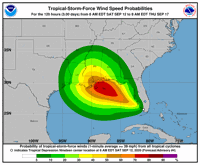
Tropical Depression 19 formed into Tropical Storm Sally in the Gulf of Mexico on Saturday, according to the National Hurricane Center, making it the earliest named "S" storm in recorded hurricane season history.
As of 1 p.m. Saturday, Sally was forecast to move through the Gulf and make landfall Tuesday along the Louisiana-Mississippi border as a low-level hurricane.
Currently located just off the Gulf coast off southern Florida near Naples, Sally is moving west at 7 mph, and has sustained maximum wind gusts of 40 mph.
Tropical Depression #Nineteen Advisory 4A: Depression Becomes a Tropical Storm. https://t.co/VqHn0u1vgc
— National Hurricane Center (@NHC_Atlantic) September 12, 2020
Forecasters said that with the stronger storm projection comes the "increasing risk of life-threatening storm surge and dangerous hurricane-force winds" between southeast Louisiana and the Alabama coast starting early next week.
At 5 a.m., they said that the areas at greatest risk from storm surge - eight to 12 feet - were between the mouth of the Mississippi River and Biloxi, Miss.. Lakes Pontchartrain and Maurepas could get four to eight feet of surge.
Portions of the New Orleans area hurricane levee system on the east bank of the Mississippi River, including in St. Bernard Parish and New Orleans East, are designed to protect from storm surge of 16½ feet to 30½ feet.
Storm surge predictions were to be updated as forecasters were able to make better predictions later in the weekend.

Beginning Sunday morning, the Hurricane Center predicted, the storm will produce three to 15 inches of rain, with localized amounts higher, in portions of southeastern Louisiana and southern Mississippi. New Orleans was expected to get six to eight inches of rain, Baton Rouge and Lafayette up to two inches.
The heaviest rain was expected to start Sunday and continue into the week, with water accumulation in low areas and spots with poor drainage making flash flooding "very possible" in southeast Louisiana.
New Orleans Sewerage & Water Board staff said Friday they were "closely monitoring" tropical weather developments over the next several days, with two of 99 drainage pumps out of commission for repairs.
One pump on Grant Street in New Orleans East is out of service pending electrical repairs, and another at Pump Station No. 13 in the southernmost tip of Algiers is under repair but was expected it to come back into service Saturday, "well ahead of major weather impacts."
In a statement, S&WB spokesperson Courtney Barnes said Saturday the system couldn't run all pumps at once, even if they all were in service.
"We would overwhelm the canals," Barnes said. "We have extra pumps which provide redundancy or 'backup' pumping capacity. Even with the pumps that are out, we have enough pump capacity to drain the city in the event of a flood."
Kevin Gilmore, a meteorologist with the National Weather Service office in Slidell, warned that the system's prediction cone encompasses all of the New Orleans metro area.
“This may be a system that’s impacting our area for a few days,” Gilmore said, adding that because of the storm's location, the temperature of the water in the Gulf and other "favorable" atmospheric conditions, rain and storm surge could both lead to "very serious flooding concerns."
Michael Lowry, a strategic planner for the Federal Emergency Management Agency, also said the storm's slow crawl was particularly worrisome.
"The slow movement later in the forecast is especially concerning for water impacts (storm surge, flooding rains)," he said on Twitter. "Louisiana to Florida keep an eye and ear to the forecast!"
The storm was also expected to produce flash flooding across portions of southern Florida and prolong minor river flooding in central Florida through Sunday, along with other portions of the central Gulf Coast region through Tuesday.
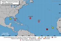
The forecast came as the National Hurricane Center was monitoring several other disturbances in the Atlantic Ocean and Gulf of Mexico, and as southwest Louisiana is still reeling from Hurricane Laura.
Laura intensified more quickly than forecasters had initially predicted before making landfall as a strong Category 4 hurricane two weeks ago near Lake Charles.
The Hurricane Center was tracking six weather disturbances in the tropics, including Tropical Storm Paulette and Tropical Depression Rene.

A tropical wave off the west coast of Africa was given an 80 percent chance of becoming a tropical depression by Monday morning and a 90 percent chance of formation by Thursday. It was unclear whether it will enter the Gulf of Mexico.
Gilmore reminded residents that it's currently the historical peak of hurricane season, which lasts from June 1 to Nov. 30. He urged everyone to have a hurricane kit with water, flashlights, food, important documents and more in place. "This is the time to be prepared," he said.
"center" - Google News
September 13, 2020 at 01:10AM
https://ift.tt/3hrbDvs
Hurricane Center: Tropical Storm Sally forms in the Gulf, see latest track here - NOLA.com
"center" - Google News
https://ift.tt/3bUHym8
https://ift.tt/2zR6ugj
Bagikan Berita Ini


0 Response to "Hurricane Center: Tropical Storm Sally forms in the Gulf, see latest track here - NOLA.com"
Post a Comment