Tropical Storm Sally seems intent on making landfall overnight Monday as a strong Category 1 hurricane just west of the Mississippi River, with 90 mph winds, dangerous storm surge and up to two feet of rainfall in some inland locations in the days that follow, the National Hurricane Center's said in its 4 p.m. Sunday update.
Sally brings with it an unusual warning of "high risk of excessive rainfall" from the Slidell office of the National Weather Service.
At 4 p.m., Sally was 165 miles south of Panama City, Florida, and 215 miles east southeast of the Mississippi River, with maximum sustained winds of 60 mph, as it moved west-northwest at 9 mph.
A somber Gov. John Bel Edwards and weather experts said Sunday Tropical Storm Sally will turn into a slow-moving, Category 2 hurricane that co…
On Sunday, Sally was taking its time getting organized as it slowly moved across the southeastern-most Gulf of Mexico. While conditions are improving for the storm to gain hurricane strength by 1 p.m. Monday, the delay also seems to have reduced the chance of it growing to Category 2 strength as it comes ashore, forecasters said.
“It appears that the northwesterly shear is beginning to relax, and the increase in convection near the center may be a harbinger of the expected strengthening phase,” said Senior Hurricane Specialist Daniel Brown, in a 4 p.m. Sunday forecast discussion message.

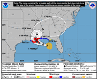
Tropical Storm Sally is expected to make landfall on the Louisiana coast late Monday night. (Image via the National Hurricane Center)
The storm is forecast to move beneath a narrow upper-level ridge of high pressure through Monday as it moves across the northeastern Gulf towards Louisiana, and that should reduce windshear that has been limiting its development, Brown said.
“Since Sally is forecast to decelerate on its approach to the northern Gulf Coast, the system still has at least another 36 hours to take advantage of the expected conducive environmental conditions,” he said.
The good news is that forecast models seem to be predicting less growth in the storm’s wind intensity, possibly because it has taken so long to become better organized. The bad news is that the storm will spend more than 24 hours to move from the mouth of the Mississippi River into northern St. Tammany Parish, and then another 12 hours to reach Jackson, Miss.
The storm is expected to have top winds of 90 mph as it enters Barataria Bay at 1 a.m. Tuesday. Sally will still have top winds of 70 mph after it very slowly swirls into the populated New Orleans area on the south shore of Lake Pontchartrain by 1 p.m. Tuesday.
By then a tropical storm, Sally will spend another dozen hours crossing Lake Pontchartrain, reaching central St. Tammany Parish by 1 a.m. Wednesday with 50 mph winds.
The storm's slow passage through southeastern Louisiana will pose major wind, surge and rainfall threats through Wednesday.
The surge threat already has prompted mandatory evacuations of Grand Isle and the Jean Lafitte-Barataria area of lower Jefferson Parish, the entire east bank and the west bank below Alliance Refinery in Plaquemines Parish.
The combined threat of surge from Lake Pontchartrain and the coast and heavy rainfall prompted a mandatory evacuation call Sunday afternoon for all of St. Charles Parish and parts of St. John the Baptist Parish north of Airline Highway.
Forecasters warn that there's still a chance for Sally to gain additional intensity before landfall, possibly increasing to Category 2 hurricane strength. And the storm's effects could spread to a much larger area than the bubble seen on forecast maps that indicate the cone of uncertainty in its forecast path.
The potential heavy rainfall could be a significant threat to locations away from the coast, including the Baton Rouge area.
The following watches and warnings are in effect locally:
-- Storm surge warning: Port Fourchon to the Mississippi/Alabama border, including Lake Pontchartrain, Lake Maurepas, and Lake Borgne.
-- A hurricane warning: Morgan City to Ocean Springs, Miss., Lake Pontchartrain and Lake Maurepas, including metropolitan New Orleans. A tropical storm warning is in effect for Amite, East Baton Rouge and East Feliciana , Iberia, Lower St. Martin, St. Mary and Vermilion parishes.
-- Storm surge watch: Mississippi/Alabama border to the Alabama/Florida border.
-- Flash flood watch: A flash flood watch is in effect for all of southeast Louisiana from 7 p.m. Sunday through Wednesday night, with potential total rainfall of up to 18 inches, with some locations seeing as much as 24 inches.

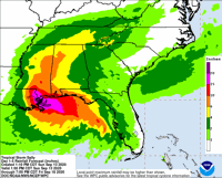
Sally is expected to move slowly and bring significant flash flooding to the central gulf coast through the middle of the week, with 8 inches to 16 inches of rain expected and up to 24 inches possible in some areas. (Image via the National Hurricane Center.)
The following are potential impacts, according to the NHC:
-- Storm surge: Areas from the mouth of the Mississippi River to Ocean Springs, Miss., could see between 7 feet and 11 feet of storm surge and the area from Port Fourchon to the mouth of the Mississippi River could see between 4 feet and 7 feet.
Lake Pontchartrain and Lake Maurepas should expect between 4 feet and 6 feet of storm surge and areas west of Port Fourchon can expect surge of 1 to 3 feet.
-- Wind: Hurricane conditions are expected starting late Monday.
-- Rainfall: Sally is expected to move slowly and bring significant flash flooding to the central gulf coast through the middle of the week, with 8 inches to 16 inches of rain expected and up to 24 inches possible in some areas.
Don't miss a storm update this hurricane season. Sign up for breaking newsletters here. Follow our Hurricane Center Facebook page here.
"center" - Google News
September 14, 2020 at 03:59AM
https://ift.tt/32qXydc
Hurricane Center: Sally on track for a dangerous Louisiana landfall: see latest rainfall forecast - NOLA.com
"center" - Google News
https://ift.tt/3bUHym8
https://ift.tt/2zR6ugj
Bagikan Berita Ini


0 Response to "Hurricane Center: Sally on track for a dangerous Louisiana landfall: see latest rainfall forecast - NOLA.com"
Post a Comment