A disturbance in the Gulf of Mexico has a 60% chance of developing into a tropical depression within five days, the National Hurricane Center said Wednesday morning.
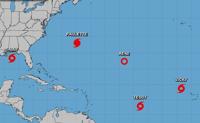
It's one of seven disturbances forecasters were tracking Wednesday, including four named storms.
Hurricane Sally made landfall early Wednesday near Gulf Shores, Alabama, as a Category 2 storm.
Forecasters also are tracking Hurricane Teddy, Tropical Storm Vicky and Post-Tropical Cyclone Paulette. These storms are not expected to pose a threat to Louisiana.

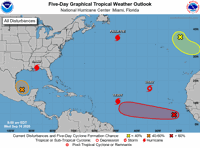
Image via National Hurricane
In addition to the disturbance in the Gulf, another tropical depression is likely to form this week in the Atlantic. If either one strengthens into a tropical storm, it will be named Wilfred - the last available name of the 2020 Atlantic hurricane season.
Once Wilfred is used, forecasters will use the Greek alphabet for naming storms this season.
Here's what to know Wednesday morning about the tropics from the National Hurricane Center.
Tropical depression possible in the Gulf

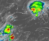
Hurricane Sally, seen at the top right, is moving over Alabama and Florida. Forecasters on Wednesday were tracking another disturbance, bottom left, in the Gulf of Mexico. (satellite image via NOAA)
An area of low pressure in the southwestern Gulf of Mexico became a little better organized Wednesday morning, forecasters said.
A tropical depression could form late this week or over the weekend while the disturbance meanders over the southern Gulf, forecasters said.
The disturbance has a 60% chance (medium) of developing into a tropical depression within five days.
The shaded area on the graphic is where a storm could develop but does not represent a projected track. The National Hurricane Center releases a track when a system develops or is about to develop into a tropical depression.
Read the latest about the disturbance.
Hurricane Sally moves inland over Alabama, Florida

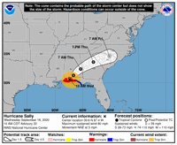
image via National Hurricane Center
Hurricane Sally made landfall early Wednesday morning as a Category 2 storm near Gulf Shores, Alabama, and now is causing "catastrophic and life-threatening flooding" in the Florida panhandle and southern Alabama, forecasters said.
Rain totals of 10-20 inches, with isolated amounts of 35 inches, are expected from west of Tallahassee, Florida, to Mobile Bay, Alabama.
As of 10 a.m., the center of Sally was about 15 miles northwest of Pensacola, Florida, and is moving northeast at 5 mph.
It has winds of 80 mph and weakening is expected as it moves inland. It's expected to be be downgraded Thursday morning to a tropical depression.
Read the latest about Hurricane Sally.
Tropical depression likely in the Atlantic

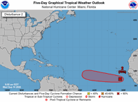
image via National Hurricane Center
A low pressure a few hundred miles southeast of the Cabo Verde Islands has a 70% chance (high) of developing into a tropical depression within five days.
It's expected to move west at 10 to 15 mph.
Hurricane Teddy forms

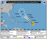
image via National Hurricane Center
Hurricane Teddy formed Wednesday morning in the Atlantic and is expected to strengthen over the next couple of days, forecasters said.
As of 10 a.m., the center of the storm was about 775 miles east of the Lesser Antilles and was moving northwest at 12 mph.
It has winds of 100 mph and is expected to strengthen into a Category 3 storm late Wednesday night.
Tropical Storm Vicky weakens

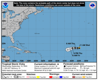
image via National Hurricane Center
Tropical Storm Vicky is weakening in the Atlantic.
As of 10 a.m., Vicky was about 795 miles northwest of the Cabo Verde Islands and was moving west at 9 mph.
It has winds of 40 mph. Vicky is expected to weaken into a tropical depression Thursday, then a remnant low on Friday and then dissipate on Saturday.
Paulette weakens in the Atlantic

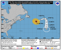
image via National Hurricane Center
Paulette has become a strong extratropical cyclone over the north Atlantic, the National Hurricane Center said Wednesday.
As of 10 a.m., the center of the storm was about 450 miles east of Cape Race, Newfoundland.
It was moving northeast at 35 mph.
Winds have decreased to 85 mph and further weakening is forecast during the next couple of days.
Read the latest about Paulette.
Disturbance in the north Atlantic

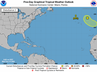
image via National Hurricane Center
An area of low pressure is in the northeast Atlantic several hundred miles northeast of the Azores, forecasters said.
This system could acquire some subtropical characteristics while it moves southeast around 10 mph during the next few days.
It has a 20% chance (low) of development within five days.
Why are the tropics are so busy?

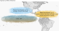
La Nina conditions mean more hurricanes in the Atlantic, the National Weather Service said.
The climatological peak of hurricane season was Sept. 10. Plus, there are favorable atmospheric conditions due to La Nina, forecasters said.
Typical La Nina influence, according to the National Weather Service, means more hurricanes in the Caribbean and Atlantic due to less atmospheric stability and weaker vertical shear and trade winds.
Read more about La Nina from the National Weather Service.
Running out of names
There's only one name left this hurricane season: Wilfred. Subsequent storms would be named after letters of the Greek alphabet.
Systems are named once they strengthen into a tropical storm.

When Tropical Storm Vicky formed Monday morning, it became the fifth named storm in the Atlantic Basin.
The first four Greek letters to be used could be Alpha, Beta, Gamma and Delta.
The Atlantic hurricane season ends Nov. 30.
Staff writer Emma Discher contributed to this story.
Don't miss a storm update this hurricane season. Sign up for breaking newsletters. Follow our Hurricane Center Facebook page.
"center" - Google News
September 16, 2020 at 10:41PM
https://ift.tt/2Ryi7yi
Hurricane Center: Tropical depression has 60% chance of forming in Gulf of Mexico - NOLA.com
"center" - Google News
https://ift.tt/3bUHym8
https://ift.tt/2zR6ugj
Bagikan Berita Ini


0 Response to "Hurricane Center: Tropical depression has 60% chance of forming in Gulf of Mexico - NOLA.com"
Post a Comment